Safe Walk of KLCCD
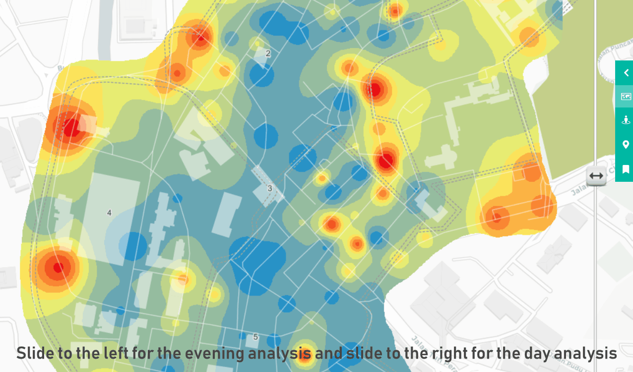
Slide right for daytime analysis and left for night-time analysis.
A study by Think City shows that 15% of public respondents didn't feel safe during the day, this number rose to 63% in the evening.
In 2018, Think City assessed the 1-km radius around Masjid Jamek in terms of
walkability and overall comfort throughout the day. The results paint an interesting picture, as shown in these two maps,
with blue indicating good scores and red indicating bad scores.
Methodology
The assessment tool was adapted from the West Perth SAFE Assessment. 32 aspects within the categories of
Safety, Accessibility, Friendliness, Efficiency, and Inclusivity were assessed for over 200 points in Downtown KL. Each point was audited 4 times on a weekday and 2 times over the weekend. Period of audit: Wednesdays, Thursdays, Saturdays and Sundays in October 2018.
Significant Trends and Key Insights
► Through a day and night comparison of the same area, we can see a central node of blue emerging. This path links the two major transit stations in Downtown KL– LRT Masjid Jamek in the north and LRT Pasar Seni in the south. This vibrant stretch is constantly used by pedestrians, relatively well-maintained, and is busy with commercial activity, even at night thanks to an active night-time economy. Notable locations include Masjid India, Dataran Merdeka and RUANG, 2HK.
► Pockets of red on the periphery during the day show high-traffic areas that are more car-centric and less pedestrian friendly. This means the paths are uncomfortable to walk along, as a result of factors such as lack of cleanliness, poorly maintained pavements and lighting, malfunctioning traffic crossings, or a lack of shade. As we transition from day to night, we see an increase in red areas.
► A stark day-time and night-time difference in perception of walkability is observed Bukit Nanas where notable educational institutions such as SMK St. Johns and SMK Convent Bukit Nanas are located. This is likely a result of decreasing number of people as students and school staff leave for home.
► Another example which shows a similar trend is the Old Railway Station area in the southern-most section of the KLCCD. Located strategically near KL Sentral and the Majestic Hotel, this area has a lot of potential for activation both during the day and night. The activation of the space would complement and enhance surrounding attractions in Downtown KL, linking it more cohesively with KL Sentral and other areas to the south and west (such as the Botanical Gardens).
Point Reference
Point 1: SMK Convent Bukit Nanas
Point 2: Masjid India
Point 3: LRT Masjid Jamek
Point 4: Dataran Merdeka
Point 5: RUANG, 2HK
Point 6: Pasar Seni
Point 7: LRT Pasar Seni
Point 8: Old Railway Station
References
Geografia & Curtin University of Technology (2006). West Perth Pedestrian Study. p.41.
Sources
Think City & Urbanmetry, 2018
Next ▶ Demographics of KLCCD

Safe Walk of KLCCD
Safety perception with regards to pedestrian walkability day and night.
-
title

-
Help
-